|
HOME |
Wey Navigation As the river gets closer to its confluence with the Thames the landscape begins to change dramatically. Open stretches of water meadows and woodland start to give way to fingers of urbanisation. Surprisingly the tranquility of this ancient waterway is preserved along much of its last few miles, still providing a feel as to what it must have been like when the Navigation was originally dug 350 years ago. |
Wey WEY WILDLIFE WEY LITERARY WEY TRAVERSE "Traversing this canal has been a challenge not unlike when we traversed the Huddersfield narrow canal in March 2004. Low water levels, untold foreign objects, reeds and lilies were a constant problem which was a bit of a let down because the locks on the canal are probably some of the best kept and maintained in the country. " NB Gypsy Rover Blog November 2006 WEY GENTEEL "I can only think of two complaints about this navigation. One is the provision of elsan emptying points. Two which we looked at today had no rinsing water supply so we didn't bother as we have spare cassettes in hand. The other is that one or two locks are a bit scary to operate. New Haw lock in particular has you standing six feet over the water on a narrow platform heaving on a rope to shut the bottom gates, then on the top gates leaning out over a wobbly gate platform to reach the swing of the long windlass you have to use. I'm surprised the health and safety mob hasn't been on to them. Maybe because everything is "listed" as of historical value they are exempt." Blogger: Neil Corbett NB Herbie 8th July 2008 MOVE ON |
|
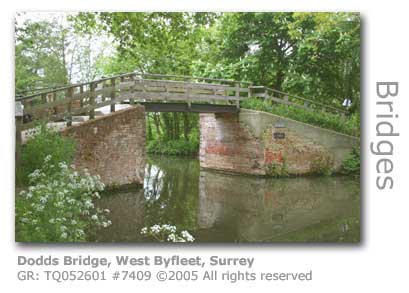
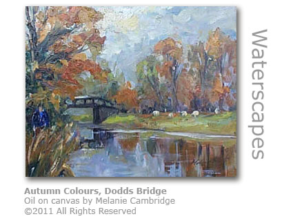
Approaching the London Sprawl The towpath alongside the Navigation and the water meadows from Dodd’s Bridge (GR:TQ052601) down to the next bridge, being a short stretch of bridleway is the only part of the path that can be used by horses ridden for pleasure as the National Trust. Regulations restrict the use of the towpath to walkers and cyclists, or any beast of burden used to tow a waterborne vessel. Dodd’s, shown as Harris’ Bridge in a map of 1823, provided an entrance to nearby West Hall (GR: TQ055605). Many of the bridges along the Wey were built and maintained by local landowners or benefactors and were often named or renamed to mark the contribution.
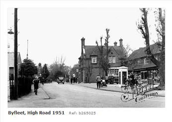
The river’s east bank begins to skirt the town of Byfleet as Murray’s Bridge (GR:TQ 058603), known as Twigs Bridge in 1823, is approached and the landscape of the Wey Valley dramatically begins to morph into an urban sprawl now under the heavy influence of London. However the magic of the Wey is not lost, and with the exception of the sound of roaring traffic coming from the eight-lane M25 motorway built to circle London and which follows the course of the Navigation for two miles (3 km), you would have little idea that the rolling fields of rural Surrey have been left far behind. Murray’s Bridge was built to provide a link the grounds of West Hall with the church in Byfleet.
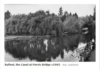
Parvis Wharves & Byfleet Mill The waterway broadens here, a reminder of the days when barges that had been using the Byfleet Wharves were ‘winded’ or turned, as it reaches the Old Parvis Bridge which was built in 1760, although little remains of the original bridge.
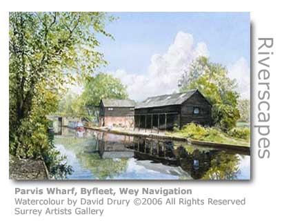
A sturdier bridge was built a little upstream to carry the A245 on its journey between the two Byfleets, and it was around this site that the wharves serviced the six mills that local historians suggest had been in operation since the 18th century along this stretch of Navigation, and the original course of the River Wey flowing a mile or so to the east. Byfleet Mill (GR: TQ073606) on the river proper has been preserved by the National Trust and was working as a grist mill up until the 20th century. The Parvis Bridge interrupts the tow path requiring a minor detour.
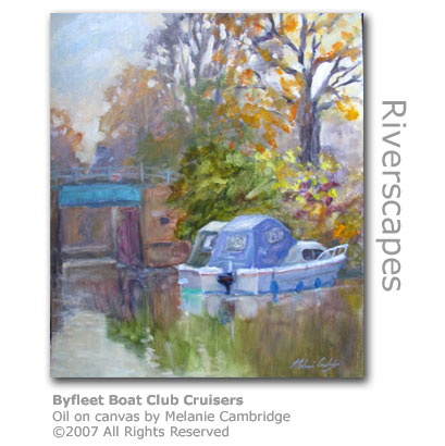
The remaining boathouse (GR: TQ056613) by Parvis Bridge is operated by Byfleet Boat Club which also rents out rowing boats to the public. One Frederick Cornelius Stoop who owned the pile at nearby West Hall bought the land where the wharves had stood, for the princely sum of £50 to preserve its usage as strictly connected to leisure boating. In the early 20th century he built two boathouses, the one now remaining being the smaller, to promote the pleasure of boating, and regularly used to hold regattas along this stretch of the Navigation for the residents of the new housing on his wife’s estate at nearby Dartnell Park. The larger more substantial boathouse that was set back from the canal on the opposite bank has since been converted for private residential use as Parvis House.
The Byfleets Two settlements sit on opposite banks of the Wey Navigation here. As you approach Murray's Bridge heading downstream Byfleet sprawls to the east nestling between the Navigation and the original course of the River Wey further east. West Byfleet lies across the fields beyond West Hall and can be easily reached from Dodd's Bridge further upstream. Byfleet ('by the river') was a Saxon manor under the Abbot of Westminster and part of the Forest of Windsor at the time of the Conquest. William I acquired Byfleet along with Windsor from the Abbot to use it as a country home and for hunting. Byfleet remained a Royal Manor until 1826 and during that time saw famous historical figures including the Black Prince and the Queen of Denmark reside there.
The Domesday Book records a church in Byfleet in 1086 and although no traces of the older church have been found it is believed likely that it was sited where the present church is. West Byfleet by name is recent when it became separated as a parish from Byfleet in 1917 indicative of it's rapid growth as a modern settlement. Prior to this the settlement was often referred to as 'West End'. A temporary corrugated iron building was erected in 1872 near to Broad Oaks and served as a church for 40 years. 'The Tin Tabernacle' could only be accessed by a plank bridge across an adjacent ditch. A permanent place of worship was built to hold a congregation of 600 and dedicated in 1912 as the Church of St Mary's. West Byfleet Golf Club was built in 1904 on land originally owned by Hugh Locke-King of nearby Brooklands fame. Junction with the Basingstoke Canal Four major routes representing the history of transportation converge here within a hundred yards. The Navigation passes under the South Western London to Portsmouth and Southampton railway originally constructed in 1838, just before meeting with the Basingstoke Canal’s easternmost stretch at Byfleet Junction (GR: TQ056620). The bridge was enlarged 46 years later to carry 4 tracks, a sign of the dramatic growth of the railway traffic that lead to the demise of both waterways. The Basingstoke Canal was constructed in the late 18th century to open up water traffic from Basingstoke to London by utilising the last few miles of the Wey Navigation. The footbridge linking the Wey Navigation towpath with the canal’s lay derelict for 30 years before being reinstated in 1988. Originally there was no footbridge here, and horses crossing over to the Basingstoke Canal had to be ferried across by boat, a difficult and often dangerous task. A waterside sign here points downstream to Thames Lock 3 miles (5km) away, upstream to Guildford at 12 miles (19 km) and Godalming 16.5 miles (26.5 km) away, and across the Wey to the Basingstoke Canal and the Greywell Tunnel 31 miles (50 km) upstream.
Wey Graffiti The huge concrete feet of the M25 overpass straddle the Wey Navigation just downstream from here casting a permanent shadow across the water and serving as a reminder that the idyllic life of olde died a long time ago. Quite why the road builders were allowed to place one of the supports so close to the canal so that any tow rope has to be passed around it is not recorded. The quite striking work of graffiti artists (GR: TQ057621) that adorns the massive concrete pillars as far up as they could reach has been left alone by the authorities, perhaps in recognition that human creativity can help soften even something so invasive as a motorway. The waterway here was raised considerably above wet heathland when it was originally constructed in the 17th century, another example of the skilful construction techniques applied in pre-machine days.
The Home of Motor Racing Not far from Byfleet is Brooklands (GR: TQ065623) straddling the River Wey proper, and the site of many aeronautical and motoring milestones during the first half of the 20th century. The Wey Navigation was excavated a mile (1.6 km) to the west of Brooklands effectively making the site an island. An airfield was constructed on Weybridge Heath at the beginning of Britain’s adventure into flight and was central to the birth of the British aviation industry. The River Wey looks lost and unwanted here now as it rushes to get away from the tarmac and concrete into prettier more natural surroundings. Many of the locks along the Wey Navigation were constructed with bricks taken after the demolition of Henry VIII’s nearby Oatlands Palace.
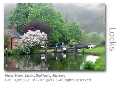
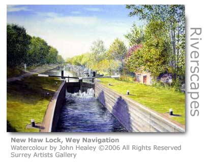
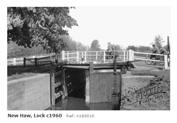
New Haw Lock After a featureless straight stretch passing by the rear of an endless row of residential properties, the Navigation reaches New Haw Lock (GR: TQ055631) - rise of 6ft 8in (2.03m). The lock, which opened in 1653, sits uncomfortably against the busy bridge that carries the A318 across this historically important crossing point and rests on the top corner of the once vast Woking Heath that inspired H G Wells (1866 – 1946) to write War of the Worlds. Wells lived near Woking station, in what was then only a small village dwarfed by the sprawling heathland all around.
The lock was one of the last along the Navigation to retain the original half-height timber walls above which the lock fell away to sloping earth covered in turf. Even in the 1980s the side of the lock closest to the towpath still had a half-height wall, albeit by now in concrete, falling away to an earth bank. The lock now has vertical sides in common with the others having finally succumbed to modern safety regulations. The Lock is 2.3 miles (3.7 km) from the Thames. The first lock keeper’s cottage was not built until 1780 with the lock being overseen by the keeper in the first century of the canal’s operation from Thames Lock. The cottage had to be substantially rebuilt after an explosion caused by a gas cylinder in 1982. The closest pub to New Haw Lock is the White Hart Inn in New Haw Road (A318) a short walk from the canal. Move on to the next stretch of the Wey Navigation: © Wey River 2005 - 2012 |