|
HOME |
The River Wey North Branch The River Wey is very unusual in that it has two sources feeding two separate rivers that share the same name. The northernmost branch rises near Alton in Hampshire and joins with its sister south of Farnham in Surrey. From there the Wey as a single river flows northwards towards the Thames. |
Wey WEY BLOG WEY POLITICAL click image to enlarge WEY DROUGHT “Our stream has been so low for many weeks that the miller at Kingsley could not grind; but was obliged to send his corn to Headleigh, where the Blackdown stream never fails. At Headleigh park-corner the Blackdown streams joins the Selborne rivulet: & at Tilford bridge they are met by the Farnham river, where together they form so considerable a body of water as within a few miles to become navigable, viz: at the town of Godalming; & there take the name of Wey." Entry for 23rd November 1790. The Natural History of Selborne - a Naturalist's Diary. Gilbert White.
MORE ON BLACKDOWN HERE |
|
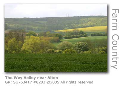
Alton Source to Historic Farnham It is not difficult to find the source of the North Branch of the River Wey. A signpost marks the edge of a Hampshire field just outside Alton, in the middle of which a spring emerges. This first trickle of water will over the next ten miles or so be joined by more and more tributaries soon ensuring that the river becomes a dependable source of water. Human settlements have used the waters since the Stone Age and the river has supported man’s endeavours in agriculture and industry ever since.
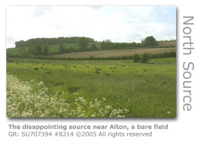
For such an important river the Wey’s North Branch source is a disappointment and barely worth a visit, unlike the source of the South Branch near Haslemere. Rising as a spring in the middle of a field (GR: SU707394) on the outskirts of the busy market town of Alton in Hampshire (MORE HERE), the trickle of water flows past South East Water’s Weysprings Treatment Works near which a sign proclaims it as ‘Source of The River Wey’. From here it heads east into the town. The first sign of how the river has been commercially used are the now defunct watercress beds in Flood Meadows (GR: SU 714396) behind Lenten Street close to the centre of town. The meadows cover 15 acres and are maintained by the town council as a semi-wild area with the help of volunteers from The Alton Society. The growing of watercress was an important industry along the Wey flourishing as transportation with London was dramatically transformed with the introduction of the railways in the 19th century. The restored Alresford to Alton railway line which formed part of this network today runs heritage steam engines hauling carriages for visitors under the name The Watercress Line, marking the importance of the industry and how much the railways were relied upon to get the crop quickly to market. Alresford, which lies 11 miles (18 km) to the southwest of Alton, organises an annual Watercress Festival with their 2008 festival marking the 200th year of watercress growing in Hampshire. Watercress is still produced in Alresford.
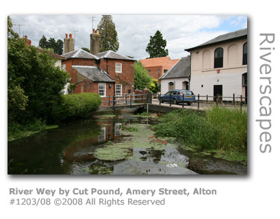
A hundred yards or so further downstream the river pauses briefly in a shallow pond by Cut Pound before disappearing into a culvert beneath Amery Street. A plaque erected nearby, featuring drawings of the river's wildlife by children from the nearby St Lawrence CofE primary school, draws attention to just how much this small river contributed to the wealth of the town.
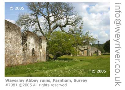
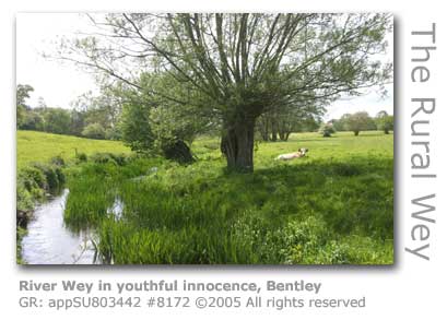
Beyond this point the fledgling river makes its way in an easterly direction across the town disappearing beneath culverts and buildings disguising the integral part the river paid in Alton's development over the centuries. The river having emerged from beneath the brewery, which has over centuries relied on its water, flows into King's Pond (MORE BELOW) alongside The Watercress Line before hurrying on through an industrial estate. The Wey doesn't fully break free from its manmade surroundings until it reaches open countryside near Holybourne, the site of a Roman settlement. The village name comes from the Old English ‘Haligburna’ meaning ‘sacred stream’ referring to a brook that rises by the ancient church of the Holy Rood (GR: SU732413). The stream is a tributary to the River Wey. The church was included in William The Conqueror's grant of the church of Alton to Hyde Abbey. It was a chapelry, together with Binsted and Kingsley, of Alton church until the 1800s, and consequentially only qualified to have a curate based there. The Cistercians (SEE WAVERLEY ABBEY) had no involvement with Holybourne apart from owning a few dwellings here that belonged to their manor of Neatham. The monks were granted permission to have an oratory (1) at the grange so that they would not have to attend Holybourne church. (1) An oratory is a small chapel or private room set aside for individual prayer. Several streams have already joined the Wey by this point and provided water power for a number of watermills along the course of the river between Alton and Farnham. An important tributary for the Wey here is Caker Stream which flows due north beneath Little Caker Bridge (GR: SU728385) and joins the river (GR: SU731401) beneath Lynch Hill. The stream's runoff is increased by effluent returns processed from a sewage works. None of the mills remain operational and most have been renovated and converted to private residences. The mill furthest upstream along the northern Wey was the fulling Orps Mill which was built above where a mill pond was to be later constructed. Kings Pond (GR: SU724395) now owned by Alton Town Council, was created in the late 1700s to provide a water reservoir for the Spital Mill which converted to milling paper in the mid-1700s. Today the pond lies in 11 acres of parkland which has been created to provide a natural habitat for many species of wildlife, flowers and trees. In 1997 the area was renovated and a hard surfaced footpath was laid to facilitate access from the car park. Anstey Mill operated near to the Caker Stream confluence with the mill house still remaining. Now within the boundaries of the town is Upper Neatham Mill (GR: SU733404), partially preserved in that the two storey 18th century mill house and a barn remain. Further downstream near Neatham Manor is Neatham Mill (GR: SU739407). Neatham Upper and Lower Mills were operating will into the 1900s, with Neatham Lower originally built to for fulling. Millcourt Mill (GR: SU755417)was built downstream from Holybourne, and although the mill house has been converted to a private residence and the mill itself was demolished. Froyle Mill and Mill House (GR: SU768428) in Lower Froyle are 18th century buildings now converted into a private residence. Isington Mill (GR: SU774427) has the distinction of having been saved from dereliction by none other than Bernard Law 1st Viscount Montgomery of Alamein. Montgomery bought the ruined watermill after the war in 1947 and completely renovated the building converting it into his private residence. Local village stories recount of how ‘Monty’ was given all manner of advice on what to do with the heavily overgrown meadow the mill stood in. Having listened politely he announced that as the turf on the meadow was many hundreds of years old it deserved to be restored, and this he painstakingly did. The resultant lawn of more than 1,000 square yards (836 square metres) was lovingly maintained to ensure that not a single weed or mole ever took hold. The long wooden building between the house and the river was where he stored his wartime caravans, now on display in the Imperial War Museum, London. Viscount Montgomery lived at Isington Mill until his death in 1976, and following his state funeral was buried in a simple grave in the churchyard at nearby Binsted Parish Church. It is always therefore a frustration in trying to gain access to the river as it meanders through private land in a rich and beautiful farming landscape as it approaches the borders with the county of Surrey. Public footpaths and bridleways do crisscross the valley but few run alongside the river itself. There is however a delightful walk along a stretch of the River Wey through some fields and a copse, bounded on one side by a forest in which wildlife thrives. In one short visit I encountered a lone fox and two roe deer, all a little jumpy as this is prime farming country and quite often these creatures and farmers have very different agendas. Leave the A31 and park up near Turks Mill (GR: SU803442). Once over the river follow the public footpath towards Holtwood Farm Bridge GR: SU812443. The mill here, today referred to as Turks Mill has buildings dating from the 18th and 19th centuries and has been renovated and converted to a private residence although the mill itself did not survive. The mill has been renamed throughout its history with reference in a 1587 will as Grove Mill. By 1664 it had become Holt Mill and milled paper, although the Isington/Binsted Popham Mill was also called Holt Mill at one time being located near the Holt. Further name changes came in the form of Groveland Mill and Bentley Mill, although being in Binsted that seems a misnomer. Towards the end of its operational life it adopted the name of the family that took it over, Turk. Overlooking the river on the other side of the valley is the village of Upper Froyle. Here in 1908 the Lord Mayor Treloar College (GR: SU755427) was founded.
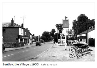
Lord Baden-Powell (1857 – 1941), founder of the scout movement, lived at Pax Hill in Bentley, a small village close to the River Wey a few miles south-west of Farnham. See more below. The owner of the White Star Line which had the fated Titanic in its fleet lived in Bentley. Harold Sanderson learned of its sinking whilst at home in Jenkyn Place. Bentley was featured in the ‘fly on the wall’ docusoap series The Village produced by Meridian TV and broadcast in October 2000. The programme followed the lives of the real villagers as they went about their daily business and it put Bentley under the spotlight for a short period. The series was syndicated to a number of countries which provided the likes of Bentley resident ‘Dave the Plumber’ with a chance to plug his singing talents (he released a CD which included the tracks We’ll Still Sing Rule Britannia and Peggy Sue’s a Granny Now.) It’s not known what became of 60 year old Dave Hurrell, or indeed his co-stars, after their brief moment of fame.
(14.040207) Acknowledgement: On the southern bank by Bentley the River Wey skirts the boundary of the Alice Holt Forest (GR: SU810420). This ancient forest, covering 2,100 acres (851 hectares) which is open to the public, was entrusted in 1924 to the management of the Forestry Commission. Alice Holt Lodge was adapted to serve as a research station in 1946. The Woodland Park in the forest has waymarked trails for both walkers and horse riders. The Forestry Commission says that Alice Holt is one of their most popular locations with 290,000 visitors estimated a year (2010). Within the forest are important habitats including Abbotts Wood with its mature oak trees and an impressive avenue of beech, Holt Pound with coniferous woodland and large open areas, Bourne Wood high on a hill with a mixture of oak, birch and pine, and Straits Inclosure providing for wet woodland. There are remains of ancient pottery kilns dating back to Roman times in the south end of the forest (GR: SU809401). General concensus suggests that Alice Holt Forest and nearby Woolmer Forest were once joined in effect as a single forested area, although today Woolmer is largely bereft of trees. Both were declared Royal Forests in the reign of William the Conqueror (1028-1087), who introduced the system of 'forest law' devised to legally control his kingdom's forests and the game animals residing in them. The first detailed survey of the two forests on record was made in 1635 which stated that their combined area was 15,493 acres (6,270 ha). Alice Holt Forest was managed from the 1770s to principally provide oak for the Royal Navy. An ambitious oak replanting programme covering 1,600 acres (650 ha) was undertaken in 1815. There are still substantial numbers of these oaks standing today, although many were felled during World War I. Post war a large conifer planting programme was instigated, with these now making up the bulk of the wood stock. There is debate as to the origins of the name of the forest. The most sensible is likely to be a corruption of Ælfsige, who as the Bishop of Winchester (AD 984) had rights over the forest, combined with the Old English 'holt' describing managed woodland. Oak from the forest was used to build the replica of Shakespeare’s Globe theatre in London, the brainchild of actor Sam Wanamaker, and which was completed in 1996. ITV1's long-running (2007 - 08) sci-fi series Primeval starring Douglas Henshaw used woodland at Alice Holt for outside locations. Alice Holt was included in the new South Down National Park (March 2010), which encompasses 14,330 acres (5,800 hectares) of woodland and open countryside, stretching 100 miles from Winchester in Hampshire to Eastbourne in East Sussex. The Forestry Commission announced (April 2010) plans to link up woodland trails with the main south coast path to benefit wallkers and cyclists.
The Forestry Commission's initiative is the creation of a new trail, the Shipwights Way marking the history the forest has played in the building of medieval naval warships. The trail will follow historic tracks that were used for hauling the felled oak timber to Portsmouth Dockyards, and will link Alice Holt Forest with the Queen Elizabeth Country Park with plans to eventually extend it to the sea at Portsmouth. Shipwrights Way when complete will cover 60 miles and form part of the Sustrans National Cycle Network route 22, which links London and Portsmouth. The first two sections were opened in March 2011 by East Hampshire MP Damien Hinds, who arrived by bicycle to the opening of the Queen Elizabeth Park section. The third trail, being the most northerly two-mile section connecting Alice Holt to Bentley railway station, opened in January 2012. Forest rangers have constructed a large wooden children's playship complete with rigging by the track in the forest. The project is a partnership between East Hampshire District Council, Hampshire County Council, the Forestry Commission and the South Downs National Park Authority. An 'interactive forest adventure trail' was opened (2011) designed specifically for wheelchair users. It is the first in the UK to be adapted for people with disabilities and will serve as the model for similar trails to be created at other Forestry Commission sites. The trail was designed with the Treloar Trust, an education organisation for young people with disabilities. Pax Hill, near Bentley village, is set in nine acres of gardens and was converted into a nursing home in 1988. Original extensions to the original building were replaced with a separate circular structure. The nursing home had a turnover of £2.8m in 2010 which the owners were hoping to double following the building work completed with a £7m bank loan. There were plans (2011) for the original red-bricked house to be converted into a museum to honour Baden-Powell. Baden-Powell lived with his wife Olave at Pax Hill from 1918 until 1938. The house was originally called Blackacre but was renamed Pax or 'peace' hill to commemorate the end of the First World War and was bought with a financial gift from Olave Baden-Powell's father, the brewery owner and artist Harold Soames. Two wings were added to the house, with the west wing designed by Baden-Powell, who also designed the frieze in one of the wing's bathrooms. The frieze depicts fish in the nearby River Wey. Scouts and Guides were regular visitors to the house with organised camps running either side of the long private drive to the house. Baden-Powell's Confidential Secretary Eileen Wade wrote about her time working at Pax Hill in her book 27 Years with Baden-Powell published in 1957.
In the book Wade describes how the Baden-Powell's had come across Blackacre by chance whilst cycling in the area looking unsuccessfully for a suitable house to buy. It proved to be a perfect choice. The following are abridged extracts from the book.
Pax Hill was requisitioned during World War II and was occupied from 1942 by Canadian troops. Baden-Powell had died the previous year and Lady BAden-Powell was provided with a 'grace and favour' apartment in Hampton Court Palace. The Girl Guides Association were given Pax Hill by Olave and used it initially as a centre for visiting Commonwealth of Nations members and later as a Domestic Science Training School. The house was sold in 1953 and returned to use as a private residence until its conversion into a nursing home in 1988. Olave St Clair Baden-Powell died in 1977 at Birtley House in Bramley, near Guildford. She was awarded the GBE (Dame Grand Cross of The Most Excellent Order of the British Empire) for her by King George V in 1932. Hampshire County Council is proposing (July 2008) to increase extraction of gravel and sand from the quarry (GR: SU780375) close to Kingsley village by a further 4.5 million tonnes per year. The increased production would require that a new quarry is dug across the road from the existing quarry near Woodland and Rookery farms. The council is under pressure to increase provision for sand and gravel extraction across the county in order to meet government imposed mineral quotas. The village has endured five decades of quarrying within its boundaries and is fearful of this being extended by the proposal. Local residents have launched the Campaign to Save Kingsley in order to marshall their efforts.
Kingsley and the quarry fall within the boundary of the proposed South Downs National Park (SDNP) and is bordered by a Site of Special Scientific Interest (SSSI). The site is three miles (4.8 km) from the River Wey. Source: © Wey River 2005 - 2012 |