|
HOME |
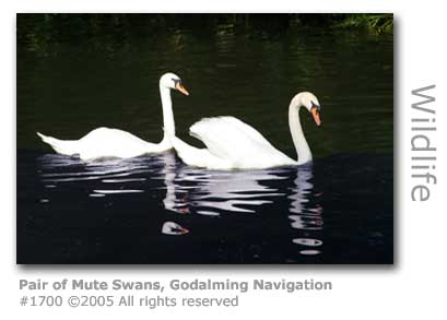
Godalming Navigation The waterway here, although not as financially successful as the older Wey Navigation, provided the key to more safely transporting volatile shipments of gunpowder from Chilworth to the magazines outside London. Accidents still happened though and there were regular explosions both at the gunpowder mills and on the river. |
Wey WEY VALLEY FOOD
WEY BOATER WEY RACER Murray, who started designing racing cars in 1964 in his native South Africa, is focusing on road cars through his Gordon Murray Design Limited and has launched the company with a city car he describes as 'a new start in small vehicle design'. The car is a small, light vehicle and able to deliver low fuel consumption with running costs cliamed to be a quarter that of an entry-level VW Golf. Murray's career has seen him working for Brabham and McLaren where he devised the F1 road car. Source: carkeys.co.uk 5th July 2007
WEY BOATER "We started from Broadford Bridge. Very soon we passed Stonebridge Wharf (formerly know as Gunpowder Wharf due to its role as a transhipment point for gunpowder produced at the powdermills at Chilworth). The wharf also marks the entrance to the Wey and Arun Canal. "Shortly, the old course of the river branches off to the left and we explored this for some way before the encroaching vegetation started to inhibit progress and we returned to the navigation channel. Soon we approached Unstead Lock. We had expected to portage but as a narrowboat was just going through (and one more close behind) we joined them in the lock for a free ride (I hate portaging). "I know some people are wary of locks but in my experience provided you stay well back from the front gates, ensure that the other boats are properly roped and avoid obvious cowboys there is unlikely to be a problem. A reminder of the potential risks, however, came from a conversation with the guy in front who had ben unable to go north through Guildford as the lock gates were unable to be opened after being rammed by an out of control narrowboat. "Leaving the Manor Inn for the way back we soon approached Catteshall Lock (there is a teashop and rowing boats to hire here) where we portaged up the steps. Another half mile brought us to Godalming Wharf followed shortly by the formal limit of navigation at Town Bridge. We continued for another half mile or so but there is much more to explore here another day. "It was time to turn for home. We arrived back at Catteshall Lock as a narrowboat prepared to empty the chamber to come up so we got another free ride down. All that remained was to negotiate the hired rowing boats before a cider at the Manor Inn and a leisurely lunch on the banks of the Wey totally on our own- if you don't count the 50 people on the horse drawn narrowboat trip! Bliss!" Blogger: Keith D songofthepaddle.co.uk 28th August 2007
WEY DRINKERS "My father especially liked the 'drawn from the wood' bit, and resolved to follow this part of the regime at least. Every night, he would go to the Parrot, drink his two pints, and sing songs with his pals. Two pints was what they liked; in Austerity Britain, you might argue, two pints was all they could afford. The point wasn't to get falling-down drunk, but to enjoy old-fashioned things such as good companionship, good cheer. WEY SCENIC (1) So the nominations are: 1. The Thames from Brentford to Weybridge - lots and lots to see, and from stately mansions to fascinating bridges to quirky boats and boathouses to channels around the numerous islands. We enjoyed it a lot. "Interesting that all three nominations this year are on rivers rather than canals. Blogger:Neil Corbett NB Herbie 9th November 2008. WEY SCENIC (2) WEY WALKER "The canal was buzzing with natural activity as well as with people. All along the way, shiny blue damselflies were buzzing around with their paddle like wings and their clumsy looking flying. Butterflies, especially fritillaries were also feeding on the waterside flowers and the cattle alongside were taking the opportunity to wander in for a drink and a cool off. "I turned left and headed down towards Stone Bridge, now occupied by the A281 and rebuilt as a result of the heavy traffic that now uses this road. Where there was once an arched bridge, this has now been strengthened by adding bricks into the arch and leaving only a culvert. It is the first obstacle that will be encountered by the preservationists along the route but not as insurmountable as the problem that exists on the other side, where the canal bed has been largely filled in and used as an ornamental stream by the private landowner. "In all likelihood this part of the canal [Wey & Arun] will have to be rebuilt entirely, probably using the Bramley Stream adjacent as the basis of the new canal. My very brief trip alongside the canal also stopped abruptly as the path now heads south using the Downs Link and the old railway line that once ran from Horsham – Guildford. Blogger: Worthing Wanderer 8th July 2009
|
|
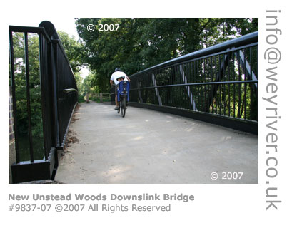
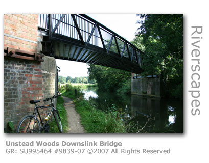
The Battle Between The National Trust has secured various parcels of riverside land along this stretch, including a 50 acre site on the east bank upstream of Unstead Lock, to provide protection for natural habitats and prevent encroachment by new developments. Just after Peasmarsh the ramparts of a disused railway bridge (GR: SU995464), long since dismantled, remain on either bank of the river. This embankment was built together with the bridge in 1852 when a company independent of the dominant London & South Western Railway (L&SWR), which had driven lines through from London to Woking, Guildford and Godalming between 1838 and 1849, decided to construct a branch line connecting Guildford with Horsham in West Sussex. Opening in 1865 the intention was to benefit from the traffic that would otherwise need to use the Wey & Arun Junction Canal, and the plan succeeded in driving the final nail in the coffin for the canal which closed a mere 6 years later. The railway line itself was closed in 1965 a casualty of the Beeching era. New Bridge Gives Access The National Trust's plans to construct a footbridge to re-join the embankment at Unstead Woods (see above) and connect to the Downslink path which follows the disused railway as it heads south towards Horsham from Stonebridge has after many decades finally been realised. On July 7th 2006 a large mobile crane attended by a team of engineers lowered the new one-piece metal bridge into place over the river. The project was funded through Surrey's Local Transport Plan and grants from Sustrans - a sustainable transport charity - and Sport England.
The path itself had had considerable attention over the last couple of years and is a level well-maintained gravel topped route.
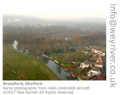
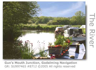
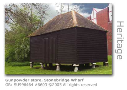
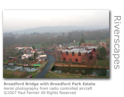
Surrey County Council and Sustrans are currently (2006) jointly preparing a regional bid to Sport England with the hope that sufficient funds can be raised to complete improvements to the entire Downslink route to the south coast. Source: The Downslink cycle route in Surrey runs along the original railway line constructed in the 1860s that connected Guildford to the south coast. Having closed as a railway in 1966 it fell into disrepair but was reopened in 1984 as a long-distance bridleway. It runs of 36 miles (58km) from St Martha's Hill near Guildford to Shoreham-by-Sea in West Sussex. The route, which links with Guildford Borough Council's Shalford Park cycle route and with the new bridge over the River Wey links to neighbouring towns and villages including Shamley Green and Godalming. Downslink forms part of the National Cycle Network route 22 and intersects with the Surrey Cycleway at Bramley. Surrey County Council has published the following local distance and time chart - with times measuring 'cycling at a steady pace from Guildford': To Bramley : 33 minutes - 4.25 miles (6.84km) Gun's Mouth Junction On the east bank just downstream of here is the Gun's Mouth Junction (GR: SU997465) where the Wey & Arun Junction Canal joins the Godalming Navigation. The canal, beyond the section of the junction cut itself after it passes under Stone Bridge (GR: TQ000463) which gives its name to the locale although no longer built of stone, is derelict and has fallen into disuse. The Wey & Arun was constructed after an Act of Parliament and opened in1816 to provide what was then regarded as a vital waterway link via the River Arun down to the south coast. Having fought to overcome considerable construction problems, and the difficulty of retaining water in the canal when it followed a natural tendency to flow out at both ends as the canal itself crossed higher ground to reach the rivers at each end, the canal was forced to close only 55 years later. This casualty of the efficiency of the railways could seek a little comfort in the fact that the Horsham line, which once crossed the bridge a little upstream, and that had taken away much of its traffic, was itself a casualty when it was closed down by the Beeching plan. MORE ABOUT THE WEY & ARUN CANAL The Wey South Long-distance Footpath joins the Navigation here having followed the route of the Wey & Arun Canal, and the Downs Link path for a stretch. The Gun’s Mouth Junction was aptly named for adjacent to the canal’s confluence with the Wey stood the gunpowder wharves (GR: SU997466) at Stonebridge that serviced the nearby Chilworth Powder Mills. Deliberately located on a remote farmland site leased from a local landowner from 1763 for 999 years, the wharves enabled barrels of highly volatile explosives to be loaded onto barges in relative safety away from any concentrations of population. This was an astute plan for there were frequent, often fatal, explosions. One such tragedy occurred in 1864 when a newly delivered barge owned by one Samuel Sharpe had been loaded at the wharf and was only one mile downstream near St Catherines when it exploded, instantly killing the bargee and his carter and sinking the vessel. Gunpowder barges, distinctive with a broad red line painted around their hulls, continued to convey their volatile cargoes from these wharves and on to the magazines at Woolwich, Purfleet and Barking Creek until 1921. There was a treadwheel crane here similar to that preserved at Town Wharf in Guildford, although this was replaced in the 1830s by an iron crane with a geared winch using chain in place of less dependable rope. Only one of the gunpowder stores (GR: SU996464) now remains, and this dark wooden boarded building that rests on stone mushrooms or ‘saddle stones’ to ensure the interior remained dry can be seen on the opposite bank to the towpath next to a business estate. The land for the estate was sold by the National Trust to the developers in 1983 provided strict compliance was made to appearance and the conservation of the river bank. As much as any development can genuinely blend into natural surroundings this one isn’t overly an eyesore. The public can access the wharf along a narrow footpath right next to the east side of the bridge and reach the gunpowder store, although the store is not open and there is sadly no explanatory display to see. Prior to this new development the site had been occupied since 1929 by a factory manufacturing vulcanised fibres and the tall brick chimney, now demolished, was a considerable eyesore. The restored 1790 cottage (GR: SU997465) just around the corner was home to the resident wharfinger. VISIT THE CHILWORTH GUNPOWDER MILLS Broadford, a small hamlet battling forever against the ruinous approaches of drivers attempting to negotiate at speed the narrow iron bridge (GR: SU996467) carrying the A248 from Shalford to Peasmarsh, takes its name from the ford that provided passage here the first bridge was built.
There had been considerable dispute with local landowners when the Navigation had been cut through here, and despite plans having been made in 1764 for a bridge this had not been constructed making passage through the now deepened ford often quite hazardous. The Navigation trustees had argued that as the track here wasn’t marked as a common byway they had no legal obligation to build one. Eventually in 1806 a bridge was grudgingly constructed, but must have been a rushed job done on the cheap because only three years later it had to be extensively repaired. The bridge used today was constructed in 1893. The Parrot (GR: SU997468) public house hides around the corner near to the entrance of the Broadford Park trading estate, and is worth a visit to sample its excellent fare. The pub also provides bed and breakfast accommodation.
Broadford Park is home to Gordon Murray Design who have designed a revolutionary new green car that is set (April 2009) to take the motoring world by storm. MORE HERE A Victorian Railway Folly 450 yards (400 m) or so further downstream on the towpath side you will encounter one of the Victorian railway barons’ little follies. Set back high above the towpath is an embankment perched on top of which is Second World War pillbox (GR: SU995472). The embankment was part of the South Eastern Railway’s master plan to connect Shalford and Godalming with the Redhill line. However the plans all went awry and this section of line was never actually laid, although the Navigation trustees had received £150 in compensation for the building of the bridge. The National Trust have cleared a Railway Walk here which follows the embankment away from the river towards the A3100 Guildford to Godalming road. The pillbox was built in 1940 high up on the embankment affording the defenders a commanding position of the waterway, and is one of many hundreds that formed a line of defence across the Wey Valley. The stretch of Navigation downstream from the iron railway bridge that crosses the Wey a little further down has cut 700 yards (640 m) through considerable contortions in the natural course of the Wey which would have provided a major challenge to the carters if they were retained. The Wey’s major tributary The Tilling Bourne joins the river proper (GR: SU996480) at the end of these meanders just before it rejoins the Navigation, bringing with it water that has flowed the nine miles (14.5 km) from Leith Hill near Dorking in Surrey, the highest point in south-east England. The railway bridge (GR: SU996473) built in 1859 runs adjacent to an equally ugly gantry for a major high pressure mains-water supply. The bridge carries the Reading via Guildford to Redhill junction line which was built 10 years after the main lines began to push through Surrey. The railway company paid the Godalming Navigation trustees £250 for the rights to build what was originally a wooden structure but has long since been replaced by this ugly iron structure. Possibly a romantic notion, but there is a story recounted by bargees who plied the Navigation here that they used to deliberately moor up beneath the bridge and wait for the trains to cross. The carriages were hauled by steam engines in those days and the drivers had to stop on the bridge to await the green signal before proceeding onto the main London to Portsmouth line. The barge crew would call up to the drivers who would hurl down a few shovel loads of coal that the bargees would use for their coal burning stoves.
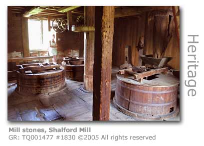
It is on the Tilling Bourne, a tributary of the Wey, in the village of Shalford just across the meadows that the National Trust have preserved the 18th century Shalford Mill (GR: TQ001477). Now under the care of the National Trust, there is an intriguing story associated with how the Trust came to receive the mill. A mysterious and secretive group calling itself The Ferguson’s Gang bought what was then a dilapidated building threatened with demolition after it fell into disuse when milling ceased there in 1914. Having raised a significant sum of money to fully restore the mill, including the waterwheel and all of its machinery, the group donated the mill to the Trust and effectively the nation. It is said that whenever they have restored a building, for these anonymous benefactors travel the country in search of suitable candidates, they will hang on to it for awhile as a venue for their secretive meetings prior to donating it to a body capable of maintaining and protecting the building for posterity. Chris Howkins, an accomplished local author, however provides a more down to earth account. Howkins has determined that the group was formed in 1927 by a band of young people who, startled by the post-war building boom which they saw as a major threat to our national heritage, brought it upon themselves to raise funds to rescue historic buildings that were under threat. By the time the Second World War had struck upon them the group had raised over £4,500 for the National Trust, a considerable amount at the time. Apparently in their twilight years the two surviving Ferguson’s Gang members decided to reveal their identities and presented a collage to the National Trust. Shalford Mill, an attractive four-storey timber framed brick and hung-tile building with traditional weather-boarding, has limited opening to the public and at the time of researching this was restricted to Wednesdays. The mill is well worth a visit, and although not a working mill, knowledgeable Trust volunteers give guided tours to provide a fascinating explanation as to how all the machinery and gearing works. For the technically minded the mill has an internal wooden low breast-shot waterwheel that powered two pairs of peak stones and one pair of French burrs. There are also several cleaning and dressing machines on display. Local artist Ernest Shepard is said to have used the mill as the setting for his famous illustration of AA Milne’s character Christopher Robin peering down into the water. MORE ON SHEPARD HERE
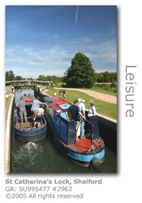
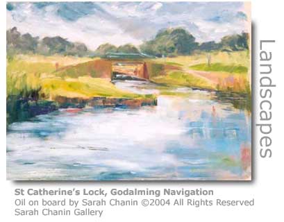
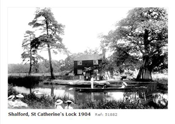
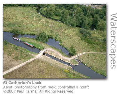
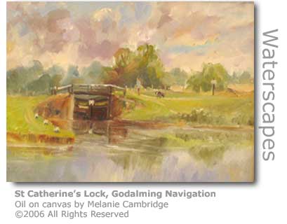
St Catherine’s Lock (GR: SU995477) - rise of 2ft 9in (0.84m) – was opened in 1764 when the Navigation started to trade and straddles the Navigation at an isolated point, providing a very picturesque setting surrounded by meadows. There is no lock-keeper’s cottage here, nor any other buildings, with the Navigation’s cottage instead being built a lot higher upstream next to a weir. This existing cottage (GR: SU996474), built at a cost of £239 in 1909 to replace the 1813 timber one (pictured below) which had become too dilapidated to repair, is located here at what is quaintly known locally as the ‘Riff-Raffs’ apparently named after some people who lived nearby and who were regarded as being unsavoury. The location enabled the keeper to attend quickly to the more critical job of controlling the level of water through the weir’s sluices.
The nearest pub to St Catherine's Lock is the Sea Horse which requires a brisk ten minutes walk along the footpath into Shalford. The pub is located in The Street on the main A281 Guildford to Horsham road near to Shalford Mill.
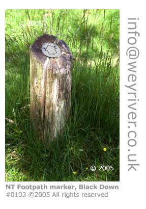
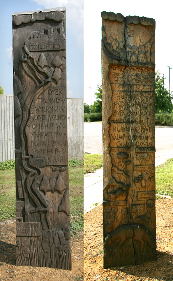
A short walk from the river here is Artington where the charity CHASE has located its specialised children's hospice Christopher's where life-limited children are able to be given some quality time with their families. The charity provides support to 240 families for which it provides its services free of charge. MORE ABOUT CHRISTOPHER'S HERE Adjacent to Christopher's and to the rear of the Artington Park & Ride a carved marker post (GR: SU994475) has been erected by the River Wey Group (1) to encourage people to explore the river just behind the site.
The 6ft (1.8m) post has been carved from solid oak to the design of artist Mary Anstee Parry, an Associate of the Royal Society of British Sculptors, and depicts local flora and fauna alongside a view of the river. A map of the river is carved onto the rear of the post. Another post has been erected by the footbridge at the bottom of St Catherine's Hill further upstream.
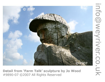
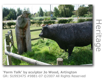
(1) The River Wey Group comprises of various public bodies, groups and individuals who have an interest in maintaining and improving the character of the river focusing particularly on the stretch between Ferry Lane in Artington to the south of Guildford and Stoke Lock to the north By the main Guildford to Godalming road (A3100) at Artington is a sculpture by Jo Wood erected to the front of the park and ride facility. 'Farm Talk' (GR: SU993475) was commissioned by the Wey Valley Rural Arts Project with the unveiling ceremony conducted in September 2004.
The Arts Project, founded in 2002, is the brainchild of Caroline Jackman who wanted to unite her passion of farming with art and raise the profile of agriculture in the valley. In addition to public sculptures the project has also created workshops providing primary school children with opportunities to learn new creative skills and increase their awareness of agriculture and the countryside. The project has also organised public exhibitions which have included displaying at the Surrey County Show and the Loseley Country Fair. Funding has been provided by the Arts Council England, Surrey County Council, Surrey Hills and Guildford Borough Council. Local landowner Michael More Molyneux (1) granted permission for the use of his land to site the sculpture. More recent funding has broadened the reach of the creative workshops to 5 to 16-year-olds including summer events every year since 2003. Tilthams Farm in Godalming has provided facilities including their 16th century barn and stable yard for these events, which sadly may cease in 2007 as Jackman has to give priority to her work commitments. (1) Michael More Molyneux is a direct descendant of the More family who built nearby Loseley House in 1562 in the reign of Queen Elizabeth I. The house is still owned by the family.
On the Old Portsmouth Road (A3100) between Godalming and Guildford is the children's hospice Christopher's. The charity CHASE who run the hospice provide a care network for life-limited children throughout Surrey, Sussex and SW London. The facility, which has nine bedrooms and four self-contained flats for visiting relatives, provides respite care for 15 days each year and full time care for children nearing the end of their lives. Also at the centre, which costs over £6,000 per day to run, are a sensory courtyard, hard and soft playrooms, computer and multi-sensory rooms and a hydrotherapy pool and jacuzzi. Remarkably the proposal in 1997 to construct the centre at Artington Manor Farm by the charity faced local opposition. Two members of the public filed planning objections and West Surrey Health Authority challenged the whole policy of providing a children's hospice. Council planners then turned down the application on the grounds that the application was to build on green belt land which was 'contrary to national, county and local planning policy'. CHASE had chosen the two-acre site as the location was accessible to its service area, was surrounded by countryside and was located by one of the park-and-ride facilities serving Guildford, which had already been built on green belt land. After a huge public outcry backed by politicians from all parties permission was eventually granted on a council chamber vote of 19 to nil and the single-storey centre was opened in November 2001 by the Countess of Wessex. The 27,000 sq ft (2,500 sq m) building, designed by architects Miller Bourne, cost £2.1m to construct. The land was donated by the More-Molyneux family at nearby Loseley Park who were friends of the charity's founder. Christopher's is named after the More-Molyneux's 12-year-old son who died in 1997 in a tragic quad-bike accident on the Loseley Estate whilst the project was in motion. A 6ft 4in (1.93m) bronze sculpture of a boy leapfrogging a globe erected on the site was created by sculptor Olwen Gillmore and donated to Christopher's by the Hon Carole Lawson in 2002. Designed to be tactile the globe allows children to explore the surface which features landmasses, animals and fish in the sea. The charity CHASE was launched by Julia Lever in 1995 to provide end-of-life care for the area where previously there had been none, and was the first to provide a home community service with a visiting nurse to provide practical and emotional support for children and their families. Currently (2008) CHASE is providing support for over 300 families and all entirely through charitable donations and fundraising. There is no charge for these services provided by 95 members of staff. Famous patrons include the publicist Max Clifford, musician Eric Clapton , music mogul Simon Cowell and cricketer Freddie Flintoff CHASE is the acronym for the Children's Hospice Association for the South East of England. The care services minister Ivan Lewis announced (February 2008) that the government is to pledge £20m for children's hospices in England to be shared between the total of 40 children's hospices in the country. The first ever government provided aid was an annual pledge of £9m in 2006 in a commitment due to finish in 2009. Prior to this hospices received no government funding at all. Christopher's costs £4m a year to run and in 2007 the charity received a total of £275,000, leaving a shortfall of £3.7 million that has to be raised through fund-raising. The hospice held an innovative fund-raising event in May 2009 in the adjoining public park and ride. Fifteen strongmen competitors raised over £2,500 in the event which saw them battling with each other to tow cars, push trucks, undertake a farmer’s walk and lifting atlas stones. The British Strongman competitor Rob Frampton provided the running commentary. Psychiatric nurse Munya Chigwada from Godalming won the intermediate category, with Colin Hawkins from reading taking the novice.
Move on to the next stretch of the Godalming Navigation: True to the tradition of the Wey Valley a 21st century car manufacturer based by the River Wey at Broadford Park in Shalford is leading the way in introducing innovative new ideas to the motor industry. Gordon Murray Design has revealed (April 2009) a prototype of their Type 25 (T25) car – so named because it is Murray’s 25th car -which is intended to be an average of 400kg (882lbs) lighter than most small cars on the road today. Through innovative use of materials and parts in the manufacturing process it is so compact that that three of the vehicles can fit in an average sized parking space, and through a lower parts count is quick to build. The development team, which was awarded Idea of the Year Award by Autocar in 2008, has also chosen a lightweight, ultra-efficient petrol engine to power the car.
South African born Murray designed and built his first car at the age of 18 in 1964 to race the Domestic Series in his native country. Five years later he moved to the UK to pursue his dream of a career in racing car design and he was to spend 17 years with Brabham Formula One and 18 years with McLaren in both Formula One and Road Car Design. Gordon Murray Design was formed in July 2007 and one year on boasted 29 employees with ‘collectively they have over 440 years working in the automotive industry and in excess of 1850 man years of co-working experience.’
The facilities in Broadford Park incorporate a design office utlising the latest technology, CAD stations and full-size drawing boards. The graphics section assists design from the very first stages of project development by producing concept sketches, 3D models and photo-realistic imaging. Their workshop is fully equipped for prototype build and development incorporating traditional skills with fully mechanized machining facilities. Recent VIP visitors to the Shalford plant have been The Duke of Edinburgh (October 2008) and Lord Paul Drayson, science minister (April 2009).
The vehicles Murray designed will only ever reach a running prototype version at Shalford. The company will then licence the technology and designs to car manufacturers who will then take the vehicles to full production under their own brand name. The motoring press have hinted that Murray’s next project may be to take a radical look at high-performance sports cars. The prototypes are backed by by American venture capitalists Mohr Davidow Ventures and the UK’s Caparo Group, with partners Prodrive providing the powertrain and vehicle development and GEO Technology the engine.
Sources: Move on to the next stretch of the Godalming Navigation: © Wey River 2005 - 2012 |