|
HOME |
Wey Navigation This stretch fittingly completes the Navigation's journey, from its original cut in the estate of Sir Richard Weston by Guildford. and on to those of the Portmore family of Weybridge who were shareholders of the Navigation for over 100 years. |
Wey WEY TRAVELOGUE WEY LEISURE WEY LIFE
I also once drove off leaving the boat pole behind on the towpath." Blogger: NB Bristol Fashion July 2006 WEY LITERARY "For a moment perhaps I stood there, breast-high in the almost boiling water, dumbfounded at my position, hopeless of escape. Through the reek I could see the people who had been with me in the river scrambling out of the water through the reeds, like little frogs hurrying through grass from the advance of a man, or running to and fro in utter dismay on the towing path. "Then suddenly the white flashes of the Heat-Ray came leaping towards me. The houses caved in as they dissolved at its touch, and darted out flames; the trees changed to fire with a roar. The Ray flickered up and down the towing path, licking off the people who ran this way and that, and came down to the water’s edge not fifty yards from where I stood. It swept across the river to Shepperton, and the water in its track rose in a boiling weal crested with steam. I turned shoreward. "In another moment the huge wave, well-nigh at the boiling-point had rushed upon me. I screamed aloud, and scalded, half blinded, agonised, I staggered through the leaping, hissing water towards the shore. Had my foot stumbled, it would have been the end. I fell helplessly, in full sight of the Martians, upon the broad, bare gravelly spit that runs down to mark the angle of the Wey and Thames. I expected nothing but death." H G Wells. War of The Worlds 1898 WEY MOAN WEY UNFORGIVING "The lock keeper arrived, just as the rain began to fall again, this time it was the drizzly stuff, you know the drizzle that gets you wetter than proper rain. We manoeuvred Hadar into the lock, tying up allowing the lock keeper to work the paddles for us, Keith on the stern and me on the bow. We then left the lock, said goodbye to the lock keeper and carried on towards the weir and Shepperton lock. "As we approached the weir, Fire and Rescue were carrying out manoeuvres and there was a fireman actually swimming across the navigation and through the weir. I thought they may be useful if we do not make this crossing successfully. The weir itself looked very mean and unforgiving, causing a very strong flow across the navigation. But not being faint hearted we went for it with me still on the bow, holding on for dear life to the fireman’s hose over the sheeting. Keith wound Hadar up and ploughed through the water. The sheer force of the water was pushing us over to the bank and some concrete steps were looming fast. Tiller over full Keith managed to get Hadar under control and we slide around the bend and back onto the Thames. On approaching Shepperton Lock, the lock keeper opened the gates and let us in along with two other boats which had come from Hampton Court. Once again we tied up in the lock and turned the engine off, whilst the lock keeper opened the paddles and let the water in. Once out of the lock it was clear there was a strong flow on the Thames and it would be hard going, especially with the wind and rain, soon after though we found a mooring place past Pharaohs Island and decided to stop for the day it was now 2.50pm. WEY VISITOR WEY SHRIEKING |
|
The larger bridge (GR: TQ067648) downstream of the old town wharf pool (GR: TQ068647) that carries the busy A317 to Addlestone and Chertsey was not built until after the last war, its completion having been delayed by the hostilities since 1939. The waterway from here down to Thames lock is the original course of the River Wey that has been excavated to make it navigable. Even as recently as 1860 this stretch would have been quite rural, but following the sale of the lands of Ham Court Manor in that year, houses were built along the bank. Today the rows of gardens backing onto the river are evidence of the huge building boom experienced in the town since. A small brick building (GR: TQ067648) next to the towpath by the bridge houses an ultrasonic gauging station that measures water flow and levels, relaying these automatically by transmitter to the water authority.
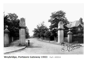
The land on the eastern bank by Weybridge was the site of Portmore Park (GR: TQ075654) that was created in the 1670s by the 6th Duke of Norfolk, Henry Howard (1628 - 1684). The duke’s widow sold it in 1688 to King James II who gave it to his mistress Catherine Sedley, the Countess of Dorchester. James spent his last night in England at the house after he was forced to abdicate in the same year to William and Mary. The countess went on to marry David Colyear (1656 – 1730), a soldier of some distinction serving William III. The king rewarded him by conferring the honour of Baron in 1699 and then an Earl in 1703, the first Earl of Portmore. Colyear bought a large number of shares in the Wey Navigation in 1723 for £3,000, and he and his descendants, along with George Langton and his descendants from Lincolnshire, controlled the canal for over 100 years. The management of the canal however had so seriously deteriorated by 1793, after subsequent control by the 2nd and 3rd Earls of Portmore, that the Chief Justices and Barons had to appoint two additional trustees to bring balance to the undertaking. Such were the ways in those days that the new appointees were directly related to the Portmore family.
It was also the third Earl that allowed the house to fall into ruin, and all that remains of the grand house and gardens of Portmore Park now are the imposing gates at the end of Portmore Road. The gates had been commissioned by the first Earl and were designed along with the house by the celebrated architect William Talman (1650 – 1719) in 1700. Thames Lock
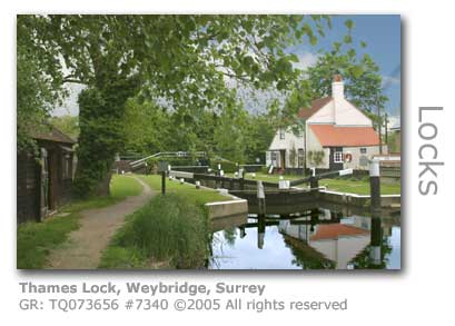
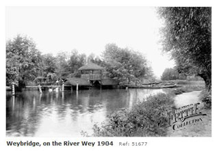
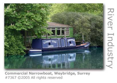
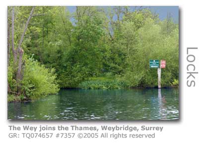
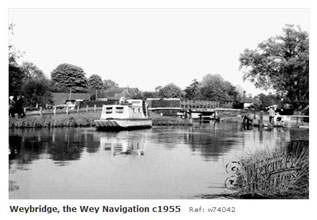
The Wey Navigation joins the Thames just upstream of Thames Lock (GR: TQ073656) - rise of 8ft 6in (2.59m), also referred to in documents as Ham Haw, with its lock-keepers cottage and small visitors’ centre housed in the old stables. The lock, which opened in 1653 was originally constructed of timber in common with other Wey Navigation locks but was rebuilt in 1863, one of the earliest uses of concrete along the river. The Victorian builders knew their craft for when the lock was drained for renovation in 1996 it was discovered that 130 years later very little attention was required. The Lock is just a tenth of a mile (0.16 km) from the Thames. A major system of three weirs have been constructed to try and minimise the chances of flooding, at one time a major problem here. The large weir alongside the mill site was added during the 1930s Improvement Scheme. Older weirs built at the end of the 18th century at Coulson’s Bay and the large Bulldogs Weir, rebuilt in 1857, now provide effective water controls. The weirs are controlled by National Trust staff based at the lock. Butler’s Boat Yard was built in the 1880s just up from Bulldogs Weir, and it was here that the ladies and gentlemen of Weybridge punted and skiffed up and down the river in their Victorian finery. The boathouse has since been converted to a private residence. The 1765 lock cottage was rebuilt in 1975 with the National Trust successfully preserving the building’s original appearance. As the entry and exit point for the Wey Navigation the lock keeper here was instrumental in collecting and recording the transit fees paid by the barge owners for using the navigation. The ledgers date back to 1739. A mill has stood on the island created by the overflow stream here since at least 1693, attracted to the location by the new manmade head of water that had been created in building the Navigation. Ham Haw Mill (GR: TQ073656), later referred to simply as Ham Mill, originally made paper, but was converted in 1720 for working local iron. In 1817 it had fallen into disuse until being revived 25 years later for crushing oil seed, at which time the mill was expanded and a second waterwheel added. The oils from various types of seeds produced here were used in the manufacture of paint and linoleum as well as providing an ingredient for foodstuffs. The solid residue of the seed kernels and flesh were compressed into oil-cake for animal feed. A series of fires so common with mills, and the last of which in 1963 was started by the highly combustible oil-cake, lead to its demolition. A residential development was constructed here in 1989. Clearly visible downstream from the pound lock is a single gate lock that was added when Sunbury Lock on the Thames was rebuilt in the 19th century. This resulted in the level of the Thames being lowered at this point and this additional gate can be closed whenever an extra depth of water is needed to allow boats using the main lock to cross the bottom cill. The closest pubs to Thames Lock are the Old Crown which is housed in a 17thC grade II listed building, and The Minnow. Both pubs are in Thames Street. The Confluence with the River Thames The waterway passes behind the Old Crown public house and out to the Thames near D’Oyly Island where it joins the Desborough Cut which was dug to shave off over a mile of the River Thames, and created Desborough Island in the process. From the bank at Weybridge the confluence with the Wey is barely visible appearing as an almost insignificant backwater only noticeable because of a sign pointing it out for waterborne users. The Tudor palace at Oatlands stood near here before it was dismantled by the Parliamentarians during the English Civil War standing as it did on Crown Land. The Harmsworth Wharf, once an extensive facility including a railway siding and crane for the loading and unloading of barges, used to stand on a spur of land here which had been an island until the present course of the waterway was dredged out in the 18th century, and the old channel was filled in with the waste. A.J. Harmsworth operated barges from here to link up with the Basingstoke Canal which he bought in 1923.
The Thames was originally tidal up to Walton-on-Thames. The construction of a series of locks including Teddington to provide more effective water control for navigation changed that and resulted in the loss of the ancient willow beds and the associated basket-making industry that had been sited here for over 1,000 years. The native yellow water lily can often be seen in abundance along the Wey Navigation here as this deep water loving plant has ample depth to flourish close to the bank and away from the destructive effect of boats and their propellers. © Wey River 2005 - 2012 |